Safaga
سفاجا | |
|---|---|
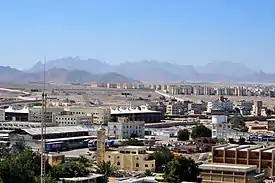  .jpg.webp)  Overview of Safaga | |
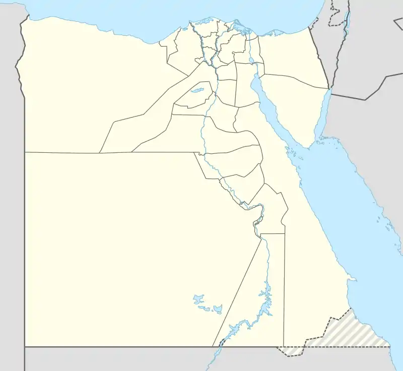 Safaga Location in Egypt | |
| Coordinates: 26°44′N 33°56′E / 26.733°N 33.933°E | |
| Country | Egypt |
| Governorate | Red Sea |
| Area | |
| • Total | 5,285 km2 (2,041 sq mi) |
| Elevation | 23 m (75 ft) |
| Population (2021)[1] | |
| • Total | 55,299 |
| • Density | 10/km2 (27/sq mi) |
| Time zone | UTC+2 (EST) |
Port Safaga, also known as Safaga (Arabic: سفاجا Safāja, IPA: [sæˈfæːɡæ]), is a town in Egypt, on the coast of the Red Sea, located 53 km (33 mi) south of Hurghada. This small port is also a tourist area that consists of several bungalows and rest houses, including the Safaga Hotel, with a capacity of 48 rooms (126 beds).
Having numerous phosphate mines, it is regarded as the phosphates export center. A paved road of 164 km (102 mi) connects Safaga to Qena of Upper Egypt.
History
The town was founded between 282 BC and 268 BC, by Satyrus (Ancient Greek: Σάτυρος).[2][3] It was called Philotera (Ancient Greek: Φιλωτέρα) in honor of the deceased sister of the Pharaoh Ptolemy II Philadelphus.[2] Stephanus of Byzantium write that it was also called Philoterida (Ancient Greek: Φιλωτερίδα).[3]
Safaga City is considered one of the most important therapeutic tourist centres, as special medical researches have proved the potential of attracting international tourism to Safaga.
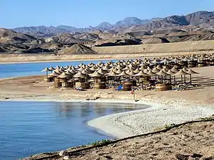
Safaga was a merchant port for many years. The town has a small tourism industry, specialising in scuba diving. It was the host of the 1993 Red Sea World Windsurfing Championships.
Climate
Köppen-Geiger climate classification system classifies its climate as hot desert (BWh),[4] as the rest of Egypt.
The highest record temperature was 46 °C (115 °F) on July 30, 2002, while the lowest record temperature was 0 °C (32 °F) on February 2, 1993.[5]
| Climate data for Safaga | |||||||||||||
|---|---|---|---|---|---|---|---|---|---|---|---|---|---|
| Month | Jan | Feb | Mar | Apr | May | Jun | Jul | Aug | Sep | Oct | Nov | Dec | Year |
| Record high °C (°F) | 33 (91) |
34 (93) |
38 (100) |
42 (108) |
43 (109) |
46 (115) |
46 (115) |
44 (111) |
43 (109) |
43 (109) |
35 (95) |
34 (93) |
46 (115) |
| Mean daily maximum °C (°F) | 21.9 (71.4) |
22.7 (72.9) |
26.1 (79.0) |
28.1 (82.6) |
31.7 (89.1) |
33.8 (92.8) |
34 (93) |
34.4 (93.9) |
32.3 (90.1) |
30.2 (86.4) |
27 (81) |
23.4 (74.1) |
28.8 (83.9) |
| Daily mean °C (°F) | 16.3 (61.3) |
16.8 (62.2) |
20.4 (68.7) |
22.5 (72.5) |
26.2 (79.2) |
28.6 (83.5) |
29 (84) |
29.6 (85.3) |
27.6 (81.7) |
25.2 (77.4) |
21.6 (70.9) |
17.9 (64.2) |
23.5 (74.2) |
| Mean daily minimum °C (°F) | 10.7 (51.3) |
11 (52) |
14.8 (58.6) |
16.9 (62.4) |
20.7 (69.3) |
23.5 (74.3) |
24.1 (75.4) |
24.9 (76.8) |
22.9 (73.2) |
20.3 (68.5) |
16.3 (61.3) |
12.4 (54.3) |
18.2 (64.8) |
| Record low °C (°F) | 1 (34) |
0 (32) |
1 (34) |
8 (46) |
10 (50) |
12 (54) |
15 (59) |
13 (55) |
12 (54) |
11 (52) |
6 (43) |
3 (37) |
0 (32) |
| Average precipitation mm (inches) | 0 (0) |
0 (0) |
0 (0) |
0 (0) |
0 (0) |
0 (0) |
0 (0) |
0 (0) |
0 (0) |
1 (0.0) |
1 (0.0) |
0 (0) |
2 (0) |
| Average rainy days | 0 | 0 | 0 | 0 | 1 | 0 | 0 | 0 | 0 | 0 | 0 | 0 | 1 |
| Mean daily sunshine hours | 9 | 10 | 10 | 10 | 11 | 12 | 13 | 12 | 11 | 10 | 10 | 9 | 11 |
| Source 1: Climate-Data.org (altitude: 18m),[4] Weather2Travel for rainy days and sunshine[6] | |||||||||||||
| Source 2: Voodoo Skies for record temperatures[5] | |||||||||||||
| Jan | Feb | Mar | Apr | May | Jun | Jul | Aug | Sep | Oct | Nov | Dec |
|---|---|---|---|---|---|---|---|---|---|---|---|
| 23 °C (73 °F) | 22 °C (72 °F) | 22 °C (72 °F) | 23 °C (73 °F) | 25 °C (77 °F) | 26 °C (79 °F) | 28 °C (82 °F) | 29 °C (84 °F) | 28 °C (82 °F) | 27 °C (81 °F) | 26 °C (79 °F) | 24 °C (75 °F) |
Port
Safaga port is also a gateway for Duba port to some hajj pilgrims or travelers to Mecca, by ferries.
See also
References
- 1 2 3 "Safājā (Kism (urban and rural parts), Egypt) - Population Statistics, Charts, Map and Location". City Population. Retrieved 17 March 2023.
- 1 2 Strabo, Geography, §16.4.5
- 1 2 Stephanus of Byzantium, Ethnica, §Ph666.16
- 1 2 "Climate: Port Safaga - Climate graph, Temperature graph, Climate table". Climate-Data.org. Archived from the original on 5 November 2013. Retrieved 13 August 2013.
- 1 2 "Safaga, Egypt". Voodoo Skies. Archived from the original on 2014-01-16. Retrieved 2014-01-15.
- 1 2 "Safaga Climate and Weather Averages, Egypt". Weather2Travel. Archived from the original on 2014-10-07. Retrieved 2014-01-15.
26°44′N 33°56′E / 26.733°N 33.933°E
| 1,000,000 and more | |
|---|---|
| 300,000–999,999 | |
| 100,000–299,999 | |
| <99,999 | |