Río Hato | |
|---|---|
 Río Hato | |
| Coordinates: 8°22′48″N 80°10′12″W / 8.38000°N 80.17000°W | |
| Country | |
| Province | Coclé |
| District | Antón |
| Area | |
| • Land | 140 km2 (50 sq mi) |
| Population (2010)[1] | |
| • Total | 15,701 |
| • Density | 112.1/km2 (290/sq mi) |
| Population density calculated based on land area. | |
| Time zone | UTC−5 (EST) |
| Climate | Aw |
Río Hato is a corregimiento in Antón District, Coclé Province, Panama. It is home to the Río Hato Airport. It has a land area of 140 square kilometres (54 sq mi) and had a population of 15,701 as of 2010, giving it a population density of 112.1 inhabitants per square kilometre (290/sq mi).[1] Its population as of 1990 was 8,888; its population as of 2000 was 10,886.[1]

Rio Hato army air base in 1940
It is the site of Scarlett Martínez International Airport, a small international airport primarily used by Canadian leisure airlines.
References
- 1 2 3 4 "Cuadro 11 (Superficie, población y densidad de población en la República...)" [Table 11 (Area, population, and population density in the Republic...)] (.xls). In "Resultados Finales Básicos" [Basic Final Results] (in Spanish). National Institute of Statistics and Census of Panama. Retrieved May 26, 2015.
Capital: Penonomé | ||
| Aguadulce | 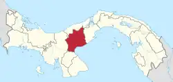 | |
| Antón | ||
| La Pintada | ||
| Natá | ||
| Olá | ||
| Penonomé |
| |
This article is issued from Wikipedia. The text is licensed under Creative Commons - Attribution - Sharealike. Additional terms may apply for the media files.