Sotang Rural Municipality
सोताङ गाउँपालिका | |
|---|---|
 | |
 Sotang Rural Municipality Location of the Municipality  Sotang Rural Municipality Sotang Rural Municipality (Nepal) | |
| Coordinates: 27°28′10″N 86°47′25″E / 27.4694°N 86.7903°E | |
| Country | Nepal |
| Province | Koshi Province |
| District | Solukhumbu District |
| Established | 10 March 2017 |
| Government | |
| • Type | Local government |
| • Body | Local executive |
| • Chairperson | Khilraj Basnet (NC) |
| • Vice-chairperson | Mrs. Anju Nachhiring Rai (NC) |
| Area | |
| • Total | 103 km2 (40 sq mi) |
| Population | |
| • Total | 9,530 |
| • Density | 93/km2 (240/sq mi) |
| Time zone | UTC+5:45 (Nepal Time) |
| Website | official website |
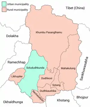
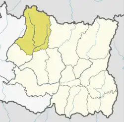
Sotang (Nepali: सोताङ) is one of the 7 rural municipalities of Solukhumbu District[1] of Province No. 1 of Nepal. It was established on 10 March 2017 merging former VDCs Sotang, Pawai and Gudel (only 2 wards of Gudel).
Total area of Sotang is 103 square kilometres (40 sq mi) and the population is 9,530, according to the 2011 census of Nepal.[2][3] Sotang is divided into 5 wards.
Sotang is surrounded by Mahakulung rural municipality in the east, Thulung Dudhkoshi rural municipality in the north-west and Mapya DudhDudhkoshi rural municipality in the south-west. It also shares part of its southern border with Khotang District.
References
- ↑ "स्थानिय तह". 31 August 2018. Archived from the original on 31 August 2018. Retrieved 3 September 2020.
- ↑ "National Population and Housing Census 2011" (PDF). 20 November 2012. Archived from the original (PDF) on 31 July 2013. Retrieved 4 July 2023.
- ↑ "Sotang Rural municipality in Nepal". www.citypopulation.de. 8 October 2017. Retrieved 8 March 2018.
External links
- Official website of the rural municipality
- www.dzi.org
This article is issued from Wikipedia. The text is licensed under Creative Commons - Attribution - Sharealike. Additional terms may apply for the media files.