Kimchaek
김책시 金策市 | |
|---|---|
| Korean transcription(s) | |
| • Chosŏn'gŭl | 김책시 |
| • Hancha | 金策市 |
| • McCune-Reischauer | Kimch'aek si |
| • Revised Romanization | Gimchaek-si |
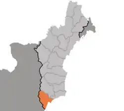 Map of North Hamgyong showing the location of Kimchaek | |
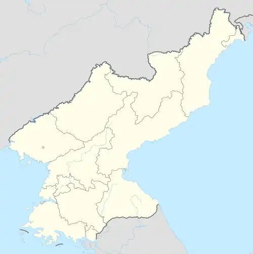 Kimchaek Location within North Korea | |
| Coordinates: 40°40′2″N 129°12′2″E / 40.66722°N 129.20056°E | |
| Country | North Korea |
| Province | North Hamgyong |
| Administrative divisions | 22 tong, 22 ri |
| Population (2008) | |
| • Total | 207,699 |
| • Dialect | Hamgyŏng |
| Time zone | UTC+9 (Pyongyang Time) |
Kimch'aek (Korean pronunciation: [kim.tsʰɛk̚]), formerly Sŏngjin (Chosŏn'gŭl: 성진, Hancha: 城津), is a city in North Hamgyong Province, North Korea. It was an open port in 1899.[1] It has a population of 207,699.
Etymology
The city received its current name in 1951 during the Korean War, in honor of the Korean People's Army (KPA) general, Kim Chaek.[1] It was known as Jōshin during Japanese rule between 1910 and 1945.
Climate
Kimchaek has a hot-summer humid continental climate (Köppen climate classification: Dfb).[2]
| Climate data for Kimchaek (1991–2020 normals, extremes 1906–present) | |||||||||||||
|---|---|---|---|---|---|---|---|---|---|---|---|---|---|
| Month | Jan | Feb | Mar | Apr | May | Jun | Jul | Aug | Sep | Oct | Nov | Dec | Year |
| Record high °C (°F) | 14.0 (57.2) |
16.7 (62.1) |
27.8 (82.0) |
35.2 (95.4) |
34.0 (93.2) |
34.3 (93.7) |
37.0 (98.6) |
36.6 (97.9) |
32.9 (91.2) |
30.2 (86.4) |
23.7 (74.7) |
17.8 (64.0) |
37.0 (98.6) |
| Mean daily maximum °C (°F) | 2.2 (36.0) |
3.2 (37.8) |
8.0 (46.4) |
14.2 (57.6) |
18.0 (64.4) |
21.0 (69.8) |
24.7 (76.5) |
26.5 (79.7) |
23.5 (74.3) |
18.2 (64.8) |
10.6 (51.1) |
4.1 (39.4) |
14.5 (58.1) |
| Daily mean °C (°F) | −3.3 (26.1) |
−1.7 (28.9) |
2.9 (37.2) |
8.4 (47.1) |
12.6 (54.7) |
16.9 (62.4) |
21.0 (69.8) |
22.6 (72.7) |
18.8 (65.8) |
12.7 (54.9) |
5.3 (41.5) |
−1.1 (30.0) |
9.6 (49.3) |
| Mean daily minimum °C (°F) | −7.9 (17.8) |
−6.5 (20.3) |
−1.5 (29.3) |
3.8 (38.8) |
8.8 (47.8) |
14.1 (57.4) |
18.6 (65.5) |
19.6 (67.3) |
14.5 (58.1) |
7.5 (45.5) |
0.5 (32.9) |
−5.7 (21.7) |
5.5 (41.9) |
| Record low °C (°F) | −26.0 (−14.8) |
−20.0 (−4.0) |
−15.0 (5.0) |
−7.1 (19.2) |
−0.5 (31.1) |
1.0 (33.8) |
9.0 (48.2) |
10.6 (51.1) |
2.8 (37.0) |
−4.0 (24.8) |
−16.6 (2.1) |
−25.1 (−13.2) |
−26.0 (−14.8) |
| Average precipitation mm (inches) | 16.7 (0.66) |
12.7 (0.50) |
16.1 (0.63) |
33.0 (1.30) |
60.5 (2.38) |
61.5 (2.42) |
147.4 (5.80) |
136.7 (5.38) |
81.8 (3.22) |
41.5 (1.63) |
36.0 (1.42) |
20.8 (0.82) |
664.7 (26.17) |
| Average precipitation days (≥ 0.1 mm) | 5.5 | 3.8 | 3.8 | 5.0 | 6.9 | 7.8 | 9.9 | 8.8 | 5.4 | 4.0 | 4.4 | 5.0 | 70.3 |
| Average snowy days | 7.2 | 4.6 | 3.8 | 0.5 | 0.1 | 0.0 | 0.0 | 0.0 | 0.0 | 0.1 | 2.3 | 5.6 | 24.2 |
| Average relative humidity (%) | 65.4 | 67.3 | 69.2 | 69.9 | 78.7 | 85.7 | 88.2 | 85.8 | 79.0 | 71.7 | 66.5 | 63.3 | 74.2 |
| Mean monthly sunshine hours | 173 | 197 | 231 | 225 | 222 | 141 | 141 | 173 | 207 | 218 | 172 | 161 | 2,261 |
| Source 1: Korea Meteorological Administration[3] | |||||||||||||
| Source 2: Deutscher Wetterdienst (sun, 1961–1990),[4][5][lower-alpha 1] Meteo Climat (extremes)[6] | |||||||||||||
Administrative divisions
Kimch'aek-si is divided into 22 tong (neighbourhoods) and 22 ri (villages):
|
|
Economy
Kimchaek is an important port on the Sea of Japan (East Sea of Korea), and is home to an ironworks and the Kimch’aek Polytechnic Institute.[1]
Transport
Kimchaek is on the Pyongra Line railway.
The city has one trolleybus line, with a length of 9.1 km, running from Songnam-dong to Haksong-dong with the depot located in Sinpyong-dong.[7][8]
Sport
Wŏlmido Sports Club, affiliated with the Ministry of Culture and Fine Arts of North Korea,[9] play at the Kimchaek Municipal Stadium, which has a capacity of 30,000. The men's team plays in the DPR Korea Premier Football League, whilst the women's team plays in the DPR Korea Women's League.
See also
Notes
- ↑ Station ID for Kimchaek is 47025 Use this station ID to locate the sunshine duration
References
- 1 2 3 "Kimch'aek". Encyclopaeida Britannica’. Retrieved 8 December 2012.
- ↑ "Kimchaek climate: Average Temperature, weather by month, Kimchaek weather averages". Climate-Data.org. Retrieved 6 November 2019.
- ↑ "30 years report of Meteorological Observations in North Korea (1991 ~ 2020)" (PDF) (in Korean). Korea Meteorological Administration. pp. 206, 282, and 343. Archived (PDF) from the original on 29 January 2022. Retrieved 23 March 2022.
- ↑ "Klimatafel von Kimchaek / Korea (Nordkorea)" (PDF). Baseline climate means (1961-1990) from stations all over the world (in German). Deutscher Wetterdienst. Retrieved 6 November 2016.
- ↑ "Station 47025 Kimchaek". Global station data 1961–1990—Sunshine Duration. Deutscher Wetterdienst. Archived from the original on 2017-10-17. Retrieved 6 November 2016.
- ↑ "Station Songjin (Kimchaek)" (in French). Meteo Climat. Retrieved 6 November 2016.
- ↑ "북한지역정보넷". www.cybernk.net. Retrieved 2021-01-28.
- ↑ "Photo: Kimchaek — Maps". transphoto.org. Retrieved 2020-10-16.
- ↑ "슛골 – 최고의 축구, 축구게임 토탈 커뮤니티에 오신것을 환영합니다. ::" (in Korean). Archived from the original on 2016-03-03. Retrieved 2012-02-23.
Further reading
- Dormels, Rainer. North Korea's Cities: Industrial facilities, internal structures and typification. Jimoondang, 2014. ISBN 978-89-6297-167-5
External links
- City profile of Kimchaek Archived 2016-03-09 at the Wayback Machine

| 2,000,000 and more |
|
|---|---|
| 1,000,000–1,999,999 |
|
| 500,000–999,999 | |
| 200,000–499,999 | |