橫瀾島 | |
|---|---|
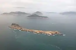 Waglan Island and the Po Toi group of islands | |
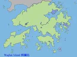 Location of Waglan Island within Hong Kong | |
| Geography | |
| Location | South China Sea |
| Area | 0.104 km2 (0.040 sq mi) |
| Administration | |
| District | Islands District |
| Demographics | |
| Population | 0 |
| Waglan Island | |||||||||||||
|---|---|---|---|---|---|---|---|---|---|---|---|---|---|
| Traditional Chinese | 橫瀾島 | ||||||||||||
| Simplified Chinese | 横澜岛 | ||||||||||||
| |||||||||||||
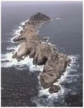
Waglan Island seen from north
Waglan Island is a member of the Po Toi group of islands in Hong Kong. It hosts a ground of meteorological observation and recording.
Climate
| Climate data for Waglan Island (1989-2016) | |||||||||||||
|---|---|---|---|---|---|---|---|---|---|---|---|---|---|
| Month | Jan | Feb | Mar | Apr | May | Jun | Jul | Aug | Sep | Oct | Nov | Dec | Year |
| Record high °C (°F) | 28.5 (83.3) |
28.8 (83.8) |
32.3 (90.1) |
33.4 (92.1) |
37.9 (100.2) |
38.4 (101.1) |
37.7 (99.9) |
38.1 (100.6) |
36.9 (98.4) |
35.1 (95.2) |
33.1 (91.6) |
29.9 (85.8) |
38.4 (101.1) |
| Mean daily maximum °C (°F) | 18.3 (64.9) |
18.6 (65.5) |
20.7 (69.3) |
24.7 (76.5) |
28.3 (82.9) |
30.4 (86.7) |
31.3 (88.3) |
31.3 (88.3) |
30.6 (87.1) |
28.2 (82.8) |
24.5 (76.1) |
20.3 (68.5) |
25.6 (78.1) |
| Daily mean °C (°F) | 15.5 (59.9) |
15.9 (60.6) |
18.0 (64.4) |
21.8 (71.2) |
25.3 (77.5) |
27.5 (81.5) |
28.2 (82.8) |
28.0 (82.4) |
27.3 (81.1) |
25.1 (77.2) |
21.5 (70.7) |
17.6 (63.7) |
22.7 (72.9) |
| Mean daily minimum °C (°F) | 13.2 (55.8) |
14.3 (57.7) |
16.3 (61.3) |
20.1 (68.2) |
23.5 (74.3) |
25.7 (78.3) |
26.0 (78.8) |
25.8 (78.4) |
24.6 (76.3) |
23.4 (74.1) |
19.7 (67.5) |
15.7 (60.3) |
20.0 (68.0) |
| Record low °C (°F) | 3.4 (38.1) |
6.0 (42.8) |
7.8 (46.0) |
10.2 (50.4) |
17.4 (63.3) |
20.2 (68.4) |
21.5 (70.7) |
21.7 (71.1) |
18.7 (65.7) |
16.1 (61.0) |
9.8 (49.6) |
4.4 (39.9) |
3.4 (38.1) |
| Source: Hong Kong Observatory[1] | |||||||||||||
Waglan lighthouse
 AWaglan lighthouse in the 1910s | |
| Location | Waglan Island, Hong Kong |
|---|---|
| Coordinates | 22°10′55″N 114°18′10″E / 22.181991°N 114.302880°E |
| Tower | |
| Constructed | 1893 |
| Construction | cast iron tower |
| Automated | 1989 |
| Height | 16 metres (52 ft) |
| Shape | cylindrical tower with balcony and lantern |
| Markings | white tower with a horizontal red band under the balcony, white lantern |
| Heritage | declared monuments of Hong Kong |
| Fog signal | two blasts every 60s. |
| Light | |
| Focal height | 69 metres (226 ft) |
| Range | 24 nautical miles (44 km; 28 mi) |
| Characteristic | Fl (2) W 20s. |
| Hong Kong no. | HK-102[2] |
The Waglan Lighthouse on Waglan Island has been listed as a declared monument of Hong Kong since 2000. It commenced operation in 1893; it is one of the five surviving pre-war lighthouses in Hong Kong.[3]
See also
References
- ↑ "Extract of Annual Data - Waglan Islandy, 1989-2016". Hong Kong Observatory. Archived from the original on 4 October 2018. Retrieved 27 February 2017.
- ↑ Rowlett, Russ. "Lighthouses of China: Hong Kong". The Lighthouse Directory. University of North Carolina at Chapel Hill. Retrieved 13 January 2016.
- ↑ "Antiquities and Monuments Office:Waglan Lighthouse". Archived from the original on 28 May 2020. Retrieved 16 October 2006.
Further reading
- Ha, Louis; Waters, Dan (2001). "Hong Kong's Lighthouses and the Men Who Manned Them" (PDF). Royal Asiatic Society Hong Kong Branch. 41: 281–320. ISSN 1991-7295.
External links
Wikimedia Commons has media related to Waglan Island.
22°10′55″N 114°18′12″E / 22.18194°N 114.30333°E
This article is issued from Wikipedia. The text is licensed under Creative Commons - Attribution - Sharealike. Additional terms may apply for the media files.