Amaraji | |
|---|---|
City | |
 Flag  Seal | |
 Amaraji | |
| Coordinates: 8°24′0″S 35°27′0″W / 8.40000°S 35.45000°W | |
| Country | Brazil |
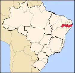
| State | Pernambuco |
| Area | |
| • Total | 234.78 km2 (90.65 sq mi) |
| Elevation | 289 m (948 ft) |
| Population | |
| • Estimate (2020 [1]) | 22,870 |
| Time zone | UTC−3 (BRT) |
Amaraji is a city located in the state of Pernambuco, Brazil. It has an estimated (IBGE 2020) population of 22,870 inhabitants.
Geography
- State - Pernambuco
- Region - Zona da mata Pernambucana
- Boundaries - Chã Grande (N); Ribeirão (S); Primavera (E); Gravatá and Cortês (W)
- Area - 234.78 km2
- Elevation - 289m
- Hydrography - Sirinhaém and Ipojuca rivers
- Vegetation - Subcaducifólia forest
- Climate - Hot tropical and humid
- Annual average temperature - 24.0 c
- Distance to Recife - 101.6 km
Economy
The main economic activities in Amaraji are based in food & beverage industry and agribusiness, especially sugarcane, bananas, manioc; and livestock such as cattle and poultry.
Economic indicators
| Population[2] | GDP x(1000 R$).[3] | GDP pc (R$) | PE |
|---|---|---|---|
| 20,509 | 71,503 | 3,549 | 0.12% |
Economy by Sector 2006
| Primary sector | Secondary sector | Service sector |
|---|---|---|
| 22.94% | 9.81% | 67.24% |
Health indicators
| HDI (2000) | Hospitals (2007) | Hospitals beds (2007) | Children's Mortality every 1000 (2005) |
|---|---|---|---|
| 0.617 | 1 | 25 | 35.3 |
References
- ↑ IBGE 2020
- ↑ http://www.ibge.gov.br/home/estatistica/populacao/estimativa2009/POP2009_DOU.pdfIBGE Population 2009 Amaraji, page 30]
- ↑ Amaraji 2007 GDP IBGE page 29 Archived March 4, 2016, at the Wayback Machine
- ↑ PE State site - City by city profile
Capital: Recife | ||||||||||||||
| Mesoregion Agreste Pernambucano |
|  | ||||||||||||
| Mesoregion Mata Pernambucana |
| |||||||||||||
| Mesoregion Metropolitana de Recife |
| |||||||||||||
| Mesoregion Sao Francisco Pernambucano |
| |||||||||||||
| Mesoregion Sertão Pernambucano |
| |||||||||||||
This article is issued from Wikipedia. The text is licensed under Creative Commons - Attribution - Sharealike. Additional terms may apply for the media files.