Ankofa | |
|---|---|
 Ankofa Location in Madagascar | |
| Coordinates: 15°24′S 49°39′E / 15.400°S 49.650°E | |
| Country | |
| Region | Analanjirofo |
| District | Maroantsetra |
| Elevation | 22 m (72 ft) |
| Population (2001)[2] | |
| • Total | 18,000 |
| Time zone | UTC3 (EAT) |
| Postal code | 512 |
Ankofa is a rural municipality in Madagascar. It belongs to the district of Maroantsetra, which is a part of Analanjirofo Region. The population of the commune was estimated to be approximately 18,000 in 2001 commune census.[2]
Only primary schooling is available. The majority 95% of the population of the commune are farmers. The most important crops are rice and vanilla; also cloves are an important agricultural product. Services provide employment for 5% of the population.[2]
Waterways
Ankofa lies at the Antainambalana River, a little upstream from Maroantsetra.
References
- ↑ Estimated based on DEM data from Shuttle Radar Topography Mission
- 1 2 3 "ILO census data". Cornell University. 2002. Retrieved 2008-03-08.
Capital: Fenoarivo Atsinanana | ||
| Fenerive Est (509) | 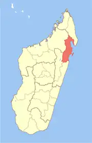 | |
| Mananara Nord (511) | ||
| Maroantsetra (512) | ||
| Sainte Marie (Nosy Boraha) (515) | ||
| Soanierana Ivongo (516) | ||
| Vavatenina (518) | ||
6 districts; 71 communes | ||
15°24′S 49°39′E / 15.400°S 49.650°E
This article is issued from Wikipedia. The text is licensed under Creative Commons - Attribution - Sharealike. Additional terms may apply for the media files.