Arethousa
Αρέθουσα | |
|---|---|
 Arethousa Location within the regional unit 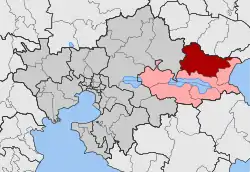 | |
| Coordinates: 40°44.6′N 23°35.4′E / 40.7433°N 23.5900°E | |
| Country | Greece |
| Administrative region | Central Macedonia |
| Regional unit | Thessaloniki |
| Municipality | Volvi |
| • Municipal unit | 214.929 km2 (82.985 sq mi) |
| Elevation | 374 m (1,227 ft) |
| Population (2011)[1] | |
| • Rural | 748 |
| • Municipal unit | 2,987 |
| • Municipal unit density | 14/km2 (36/sq mi) |
| Community | |
| • Population | 869 (2011) |
| • Area (km2) | 57.021 |
| Time zone | UTC+2 (EET) |
| • Summer (DST) | UTC+3 (EEST) |
| Postal code | 570 02 |
| Area code(s) | +30-2395-xxx-xxx |
| Vehicle registration | NAx-xxxx to NXx-xxxx |
Arethousa (Greek: Αρέθουσα) is a village and a community and a municipal unit of the Volvi municipality.[2] Before the 2011 local government reform it was part of the municipal unit of Arethousa was an independent municipality.[2] The 2011 census recorded 748 inhabitants in the village, 869 in the community and 2,987 inhabitants in the municipal unit.[1] The community of Arethousa covers an area of 57.021 km2 while the respective municipal unit 214.929 km2.[3]
Administrative division
The community of Arethousa consists of two separate settlements:[1]
- Arethousa (population 748)
- Lefkouda (population 121)
The aforementioned population figures are as of 2011.[1]
See also
References
- 1 2 3 4 5 "Απογραφή Πληθυσμού - Κατοικιών 2011. ΜΟΝΙΜΟΣ Πληθυσμός" (in Greek). Hellenic Statistical Authority.
- 1 2 "ΦΕΚ B 1292/2010, Kallikratis reform municipalities" (in Greek). Government Gazette.
- ↑ "Population & housing census 2001 (incl. area and average elevation)" (PDF) (in Greek). National Statistical Service of Greece. Archived from the original (PDF) on 2015-09-21.
This article is issued from Wikipedia. The text is licensed under Creative Commons - Attribution - Sharealike. Additional terms may apply for the media files.