Bemina | |
|---|---|
Town | |
 Bemina Location in Jammu and Kashmir, India  Bemina Bemina (India) | |
| Coordinates: 34°3′12″N 74°45′43″E / 34.05333°N 74.76194°E | |
| Country | |
| Union territory | Jammu and Kashmir |
| District | Srinagar |
| Government | |
| • Body | Government of Jammu and Kashmir |
| Elevation | 1,585 m (5,200 ft) |
| Languages | |
| • Official | Kashmiri, Urdu, Hindi, Dogri, English[1][2] |
| Time zone | UTC+5:30 (IST) |
| Postal Code | 190018 |
| Vehicle registration | JK |
| Website | srinagar |
Bemina is a region in the city of Srinagar, the summer capital of Jammu and Kashmir, India. It is in the heart of the summer capital of Jammu and Kashmir just about 4 km (2.5 mi) from Lal Chowk. It lies in the Batamaloo Assembly Constituency, Batamaloo assembly segment of the Srinagar parliamentary constituency.
Etymology
History
Bemina was a nabal before it was developed by srinagar development authority .[3]
Flood plain
Bemina was settled on the local floodplains of adjoining rivers. Unplanned and haphazard construction led to usurpation of flood plains. A direct consequence of this is that it is one of the most flood prone areas in the Srinagar city.[5]
References
- ↑ "The Jammu and Kashmir Official Languages Act, 2020" (PDF). The Gazette of India. 27 September 2020. Retrieved 27 September 2020.
- ↑ "Parliament passes JK Official Languages Bill, 2020". Rising Kashmir. 23 September 2020. Archived from the original on 24 September 2020. Retrieved 23 September 2020.
- 1 2 Raina, Mohini Qasba (13 November 2014). Kashur The Kashmiri Speaking People. Partridge Publishing Singapore. ISBN 978-1-4828-9945-0.
- ↑ Rabbani, G. M. (1986). Kashmir, social and cultural history. Anmol Publications. p. 29.
- ↑ "How conversion of Bemina from flood basin to residential area endangered Srinagar | Free Press Kashmir". 4 October 2017.
| Passes | 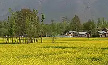 | |
|---|---|---|
| Valleys | ||
| Cities | ||
| Towns |
| |
| Rivers | ||
| Glaciers | ||
| Lakes | ||
| Mountains | ||
| Hill stations and Mughal gardens | ||
| Protected Areas | ||
| See also | ||
This article is issued from Wikipedia. The text is licensed under Creative Commons - Attribution - Sharealike. Additional terms may apply for the media files.