| Ben Armine | |
|---|---|
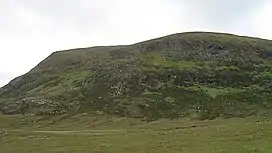
| Creag a' Choire Ghlais | |
 Ben Armine summit | |
| Highest point | |
| Elevation | 705 m (2,313 ft)[1] |
| Prominence | 243 m (797 ft) |
| Listing | Graham, Marilyn |
| Geography | |
| Location | Sutherland, Scotland |
| Parent range | Northwest Highlands |
| OS grid | NC695273 |
| Topo map | OS Landranger 16 |
Ben Armine (705 m) is a remote hill in Sutherland in the far north of Scotland. It lies in inland, north of the village of Lairg.
The best known summit of a range of hills lying southeast of Ben Klibreck, its southern neighbour Creag Mhor is slightly higher.[2]
References
- ↑ "Ben Armine". hill-bagging.co.uk. Retrieved 19 June 2019.
- ↑ "walkhighlands Ben Armine". walkhighlands.co.uk. Retrieved 19 June 2019.
58°12′54″N 4°13′26″W / 58.215°N 4.224°W
This article is issued from Wikipedia. The text is licensed under Creative Commons - Attribution - Sharealike. Additional terms may apply for the media files.