Aït Douala
Larba n’Aït Dwala | |
|---|---|
Commune and town | |
 | |
 | |
 Aït Douala | |
| Coordinates: 36°37′N 4°05′E / 36.617°N 4.083°E | |
| Country | |
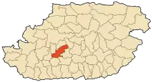
| Province | Tizi Ouzou Province |
| District | Béni Douala District |
| Population (2008) | |
| • Total | 21,555 |
| Time zone | UTC+1 (CET) |
Beni Douala is a town and commune in Tizi Ouzou Province in northern Algeria.[1] At Dwala, or Aït Douala (At Dwala in Kabyle), is located 17 km south-east of Tizi-Ouzou.
Villages in the commune
At its creation, in 1984, the commune of At Dwala was composed of the following eighteen localities.[2] :
- Thala Bounane
- Ighil Bezrou
- Thighzert
- Aguemoun
- Thabarkoukth
- Thamaright
- (Ait Ɛli Waɛli) Aït Ali Ouali
- (Ath Bu Yehya) Ait Bouyahia
- Amsiouene (Amsiwen)
- (Ait Bu Ɛli) Aït Bouali
- Aït Hellal
- (Ait Yidir) Aït Idir
- Ait Mesbah
- Aït Douala
- (Ichardiwen Oufella) Icherdiouene Oufella
- Taguemount Oukerrouch
- (Tamaɣuct) Tamaghoucht (Tamaɣuct)
- Ighil Mimoun
- Taboudrist
- Thaddarth Oufella
- Tala Khelil
- Tchardioune Bedda
References
- ↑ "Communes of Algeria". Statoids. Retrieved December 12, 2010.
- ↑ Journal officiel de la République Algérienne, 19 décembre 1984. Décret No. 84-365, fixant la composition, la consistance et les limites territoriale des communes. Wilaya de Tizi Ouzou, page 1504.
.svg.png.webp)
This article is issued from Wikipedia. The text is licensed under Creative Commons - Attribution - Sharealike. Additional terms may apply for the media files.