Biwer
Biwer | |
|---|---|
 | |
 Coat of arms | |
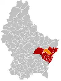 Map of Luxembourg with Biwer highlighted in orange, and the canton in dark red | |
| Coordinates: 49°42′25″N 6°22′20″E / 49.7069°N 6.3722°E | |
| Country | |
| Canton | Grevenmacher |
| Area | |
| • Total | 23.08 km2 (8.91 sq mi) |
| • Rank | 42nd of 102 |
| Highest elevation | 332 m (1,089 ft) |
| • Rank | 91st of 102 |
| Lowest elevation | 210 m (690 ft) |
| • Rank | 30th of 102 |
| Population (2023) | |
| • Total | 1,926 |
| • Rank | 81st of 102 |
| • Density | 83/km2 (220/sq mi) |
| • Rank | 74th of 102 |
| Time zone | UTC+1 (CET) |
| • Summer (DST) | UTC+2 (CEST) |
| LAU 2 | LU0001102 |
| Website | biwer.lu |
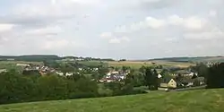
Biwer is a commune and small town in eastern Luxembourg. It is part of the canton of Grevenmacher. As of 2021, the commune has a population of 1,884 inhabitants.
As of June 2018, the town of Biwer, which lies in the east of the commune, has a population of 1,403 inhabitants.[1] Other localities within the commune include, Boudler, Brouch, Hagelsdorf, Wecker, and Weydig.[1]
Population
References
- 1 2 "La commune se présente". Administration Communale de la commune de Biwer (in French). Retrieved 2 July 2018.
- ↑ "Population par canton et commune". statistiques.public.lu. Archived from the original on 2016-09-12. Retrieved 11 January 2022.
External links
 Media related to Biwer at Wikimedia Commons
Places adjacent to Biwer | |
|---|---|
 | ||
This article is issued from Wikipedia. The text is licensed under Creative Commons - Attribution - Sharealike. Additional terms may apply for the media files.