50°21′00″N 4°45′58″W / 50.350°N 4.766°W
Phernyssick Road, Boscoppa
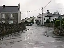
Boscoppa (Cornish: Boskoppa)[1] is a settlement in the amalgamation of St Austell in Cornwall, England, United Kingdom.[2] Originally Boscoppa was a separate village but is now a suburb of St Austell (Cornwall's largest town) and is west of the recently built A391 bypass road. The village lies in a former mining area.[3]
References
- ↑ Place-names in the Standard Written Form (SWF) Archived 2013-05-15 at the Wayback Machine : List of place-names agreed by the MAGA Signage Panel Archived May 15, 2013, at the Wayback Machine. Cornish Language Partnership.
- ↑ Ordnance Survey: Landranger map sheet 200 Newquay & Bodmin ISBN 978-0-319-22938-5
- ↑ Ancestry.com website; St Austell Parish pages; retrieved March 2010
External links
![]() Media related to Boscoppa at Wikimedia Commons
Media related to Boscoppa at Wikimedia Commons
| Unitary authorities | |
|---|---|
| Major settlements (cities in italics) |
|
| Rivers | |
| Topics | |
This article is issued from Wikipedia. The text is licensed under Creative Commons - Attribution - Sharealike. Additional terms may apply for the media files.