| Castle Peak | |
|---|---|
 | |
| Highest point | |
| Elevation | 11,305 ft (3,446 m)[1][2] |
| Prominence | 3,040 ft (927 m)[2] |
| Isolation | 16.70 mi (26.88 km)[2] |
| Listing | Colorado prominent summits |
| Coordinates | 39°46′23″N 106°50′04″W / 39.7730422°N 106.8344844°W[3] |
| Geography | |
 Castle Peak | |
| Location | Eagle County, Colorado, U.S.[3] |
| Parent range | Sawatch Range[2] |
| Topo map | USGS 7.5' topographic map Castle Peak, Colorado[3] |
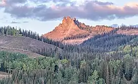
Castle Peak is a prominent mountain summit in the northern Sawatch Range of the Rocky Mountains of North America. The 11,305-foot (3,446 m) peak is located 9.6 miles (15.5 km) north (bearing 355°) of the Town of Eagle in Eagle County, Colorado, United States.[1][2][3]
See also
References
- 1 2 The elevation of Castle Peak includes an adjustment of +1.575 m (+5.17 ft) from NGVD 29 to NAVD 88.
- 1 2 3 4 5 "Castle Peak, Colorado". Peakbagger.com. Retrieved October 19, 2014.
- 1 2 3 4 "Castle Peak". Geographic Names Information System. United States Geological Survey, United States Department of the Interior. Retrieved October 19, 2014.
External links
Denver (capital) | |
| Topics |
|
| Society | |
| Cities |
|
| Counties |
|
| Regions |
|
| Federal |
| ||||||||||||||||||||||||||||||||
|---|---|---|---|---|---|---|---|---|---|---|---|---|---|---|---|---|---|---|---|---|---|---|---|---|---|---|---|---|---|---|---|---|---|
| State |
| ||||||||||||||||||||||||||||||||
| Trails |
| ||||||||||||||||||||||||||||||||
This article is issued from Wikipedia. The text is licensed under Creative Commons - Attribution - Sharealike. Additional terms may apply for the media files.