Chicago, Kansas | |
|---|---|
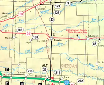 KDOT map of Sheridan County (legend) | |
 Chicago  Chicago | |
| Coordinates: 39°29′00″N 100°15′23″W / 39.48333°N 100.25639°W | |
| Country | United States |
| State | Kansas |
| County | Sheridan |
| Township | Adell |
| Named for | Chicago, Illinois |
| Elevation | 2,657 ft (810 m) |
| Population | |
| • Total | 0 |
| Time zone | UTC-6 (CST) |
| • Summer (DST) | UTC-5 (CDT) |
| Area code | 785 |
| GNIS ID | 482591[1] |
Chicago is a ghost town in Adell Township, Sheridan County, Kansas, United States.
History
The community was named after Chicago, Illinois because it was the busiest place in the local area. A joint post office, stagecoach stop, and general store opened in 1880. The post office only lasted until 1887. A church built in 1910 lasted until the early 1960s, and the local school closed in 1954.
Currently, what remained of the community is an abandoned schoolhouse, a rusty "Chicago" sign marker, and the foundation of an abandoned home.[2]
References
Further reading
External links
- 1965 photograph of church and school, Kansasmemory.com
- Sheridan County maps: Current, Historic, KDOT
Municipalities and communities of Sheridan County, Kansas, United States | ||
|---|---|---|
| Cities | 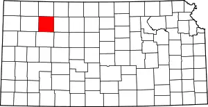 Map of Kansas highlighting Sheridan County | |
| Unincorporated communities | ||
| Ghost towns | ||
| Townships | ||
This article is issued from Wikipedia. The text is licensed under Creative Commons - Attribution - Sharealike. Additional terms may apply for the media files.