| Coniston Cold | |
|---|---|
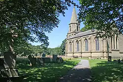 St Peter's Church | |
.svg.png.webp) Coniston Cold Location within North Yorkshire | |
| Population | 203 (2011 census)[1] |
| OS grid reference | SD903550 |
| Civil parish |
|
| Unitary authority | |
| Ceremonial county | |
| Region | |
| Country | England |
| Sovereign state | United Kingdom |
| Post town | SKIPTON |
| Postcode district | BD23 |
| Dialling code | 01756 |
| Police | North Yorkshire |
| Fire | North Yorkshire |
| Ambulance | Yorkshire |
| UK Parliament | |
Coniston Cold is a village and civil parish in the Craven district of North Yorkshire, England. Historically part of the Staincliffe Wapentake of the West Riding of Yorkshire, the village lies 7 miles (11 km) north-west of Skipton along the A65.[2]
According to the 2001 UK census, Coniston Cold parish had a population of 186,[3] increasing to 203 at the 2011 Census.[1]
References
- 1 2 UK Census (2011). "Local Area Report – Coniston Cold Parish (1170216736)". Nomis. Office for National Statistics. Retrieved 25 March 2018.
- ↑ "OL2" (Map). Yorkshire Dales - Southern & Western Area. 1:25,000. Explorer. Ordnance Survey. 2016. ISBN 9780319263310.
- ↑ "2001 Census: Key Statistics: Parish Headcounts: Area: Coniston Cold CP (Parish)". Neighbourhood Statistics. Office for National Statistics. Retrieved 1 April 2009.
External links
![]() Media related to Coniston Cold at Wikimedia Commons
Media related to Coniston Cold at Wikimedia Commons
This article is issued from Wikipedia. The text is licensed under Creative Commons - Attribution - Sharealike. Additional terms may apply for the media files.