Dawson Bridge | |
|---|---|
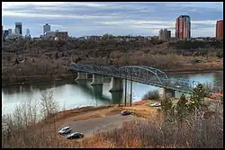 Dawson Bridge as of 2008 | |
| Coordinates | 53°32′55.6″N 113°28′1.2″W / 53.548778°N 113.467000°W |
| Carries | Motor vehicles, pedestrians |
| Crosses | North Saskatchewan River |
| Locale | Edmonton, Alberta, Canada |
| Official name | Dawson Bridge |
| Characteristics | |
| Total length | 236.5 m (776 feet) |
| Width | 12.5m (41 feet) |
| History | |
| Opened | 1912 |
| Location | |
The Dawson Bridge is a two lane bridge that spans the North Saskatchewan River in Edmonton, Alberta, Canada.
In early 2010, it underwent repairs, and later reopened on December 20, 2010.[1]
Dawson Bridge connects the communities of Forest Heights on the east end to Riverdale on the west end.
See also
References
Wikimedia Commons has media related to Dawson Bridge.
- ↑ "Dawson Bridge to reopen Monday". CBC.ca. December 17, 2010. Retrieved January 23, 2011.
This article is issued from Wikipedia. The text is licensed under Creative Commons - Attribution - Sharealike. Additional terms may apply for the media files.