Gogogogo | |
|---|---|
 Gogogogo Location in Madagascar | |
| Coordinates: 24°16′S 44°48′E / 24.267°S 44.800°E | |
| Country | |
| Region | Atsimo-Andrefana |
| District | Ampanihy |
| Elevation | 341 m (1,119 ft) |
| Population (2019)Census | |
| • Total | 19,454 |
| Time zone | UTC3 (EAT) |
Gogogogo is a rural municipality in southwestern Madagascar. It belongs to the district of Ampanihy, which is a part of Atsimo-Andrefana. The population of the municipality was 20,021 in 2023.
Only primary schooling is available. About 60% of the population are farmers, while an additional 15% make their livelihood from raising livestock. The most important crop is cassava, while other important products are peanuts, maize, sweet potatoes and cowpeas. Services provide employment for 25% of the population.[2] There are also some mineral resources in the area.[3]
References
- ↑ Estimated based on DEM data from Shuttle Radar Topography Mission
- ↑ "ILO census data". Cornell University. 2002. Retrieved 2008-03-11.
- ↑ "Gogogogo (B1) Mining Property | PropertyMine". Global InfoMine. 2008. Retrieved 2008-04-21.
Capital: Toliara | ||
| Ampanihy Ouest (19) - 605 | 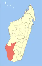 | |
| Ankazoabo - 606 - (10) |
| |
| Benenitra - 610 - (6) |
| |
| Beroroha - 611 - (9) |
| |
| Betioky-Atsimo -612 - (31) |
| |
| Morombe (9) - 618 | ||
| Sakaraha (12) - 620 | ||
| Toliara I (1) | ||
| Toliara II (22) (602) | ||
9 districts; 119 communes | ||
24°16′S 44°48′E / 24.267°S 44.800°E
This article is issued from Wikipedia. The text is licensed under Creative Commons - Attribution - Sharealike. Additional terms may apply for the media files.