| Site of Special Scientific Interest | |
 | |
| Location | Norfolk |
|---|---|
| Grid reference | TG 087 374[1] |
| Interest | Biological |
| Area | 49.9 hectares (123 acres)[1] |
| Notification | 1986[1] |
| Location map | Magic Map |
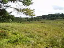
Holt Lowes is a 49.9-hectare (123-acre) biological Site of Special Scientific Interest west of Cromer in Norfolk.[1][2] It is a Nature Conservation Review site, Grade 2,[3] and part of the Norfolk Valley Fens Special Area of Conservation.[4]
This site is mainly dry and sandy heath in the valley of the River Glaven, with a mire along a tributary which runs through the heath. Ground flora includes wood horsetail at its only known location in East Anglia.[5]
The site is open to the public.
References
- 1 2 3 4 "Designated Sites View: Holt Lowes". Sites of Special Scientific Interest. Natural England. Retrieved 12 June 2018.
- ↑ "Map of Holt Lowes". Sites of Special Scientific Interest. Natural England. Retrieved 12 June 2018.
- ↑ Ratcliffe, Derek, ed. (1977). A Nature Conservation Review. Vol. 2. Cambridge, UK: Cambridge University Press. p. 140. ISBN 0521-21403-3.
- ↑ "Designated Sites View: Norfolk Valley Fens". Special Areas of Conservation. Natural England. Retrieved 25 May 2018.
- ↑ "Holt Lowes citation" (PDF). Sites of Special Scientific Interest. Natural England. Retrieved 12 June 2018.
This article is issued from Wikipedia. The text is licensed under Creative Commons - Attribution - Sharealike. Additional terms may apply for the media files.