Katlakalns | |
|---|---|
Neighborhood of Riga | |
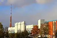 The Riga Milk Factory in Katlakalns | |
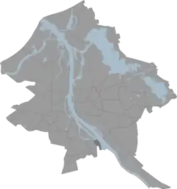 Location in Riga | |
| Country | Latvia |
| City | Riga |
| District | Zemgale Suburb |
| Area | |
| • Total | 1.554 km2 (0.600 sq mi) |
| Population (2018) | |
| • Total | 144 |
| • Density | 93/km2 (240/sq mi) |
| Time zone | UTC+2 (EET) |
| • Summer (DST) | UTC+3 (EEST) |
| Website | apkaimes.lv |
Katlakalns is a neighbourhood of Riga, the capital of Latvia. It is linked to Ķengarags and Maskavas forštate by the Southern Bridge erected in 2004-2008 and opened on November 17, 2008.[1][2]
Katlakalns village of Ķekava parish also belongs to this neighborhood.
References
- ↑ "Katlakalns. Apkaimes vēsturiskais apraksts". apkaimes.lv. Retrieved May 14, 2015.
- ↑ "Katlakalns. Fizģeogrāfiskais raksturojums". apkaimes.lv. Retrieved May 14, 2015.
Sources
- Jērāns, Pēteris (1988). Latvijas padomju enciklopēdija: Rīga. Rīga: Valērija Belokoņa izdevniecība. p. 733. ISBN 9984-9482-2-6.
56°53′N 24°11′E / 56.883°N 24.183°E
This article is issued from Wikipedia. The text is licensed under Creative Commons - Attribution - Sharealike. Additional terms may apply for the media files.