Oulad Teima
ⵡⵍⴰⴷ ⵜⴻⵢⵎⴰ or ⵀⵓⵡⴰⵔⴰ | |
|---|---|
Town | |
 Souss-Massa | |
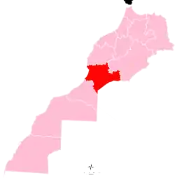
 Oulad Teima Location in Morocco  Oulad Teima Oulad Teima (Africa) | |
| Coordinates: 30°24′N 9°13′W / 30.400°N 9.217°W | |
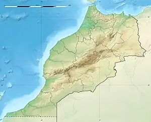
| Country | |
| Region | Souss-Massa |
| Province | Taroudannt |
| Population (2014)[1] | |
| • Total | 89,387 |
| Time zone | UTC+0 (WET) |
| • Summer (DST) | UTC+1 (WEST) |
Oulad Teima also known as Houara (Berber: ⵡⵍⴰⴷ ⵜⴻⵢⵎⴰ or ⵀⵓⵡⴰⵔⴰ) is a city in Taroudant Province, Souss-Massa, Morocco. According to the 2014 Moroccan census it had a population of 89,387,[1] up from 66,183 in the 2004 census.[2]
Vegetation
Ouled Teima is surrounded by agricultural areas marked by farms and fields with different crops. A belt formed by a forest area with a predominance of argans can also be noted.
References
- 1 2 "POPULATION LÉGALE DES RÉGIONS, PROVINCES, PRÉFECTURES, MUNICIPALITÉS, ARRONDISSEMENTS ET COMMUNES DU ROYAUME D'APRÈS LES RÉSULTATS DU RGPH 2014" (in Arabic and French). High Commission for Planning, Morocco. 8 April 2015. Retrieved 29 September 2017.
- ↑ "World Gazetteer". Archived from the original on 2012-12-10.
Capital: Agadir | ||
| Provinces and prefectures | | |
| Cities | ||
This article is issued from Wikipedia. The text is licensed under Creative Commons - Attribution - Sharealike. Additional terms may apply for the media files.