Picacho, Arizona | |
|---|---|
Census-designated place | |
 Picacho post office (Demolished) | |
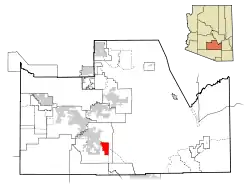 Location in Pinal County and the state of Arizona | |
 Picacho, Arizona Location in the United States | |
| Coordinates: 32°42′58″N 111°29′43″W / 32.71611°N 111.49528°W | |
| Country | United States |
| State | Arizona |
| County | Pinal |
| Area | |
| • Total | 6.11 sq mi (15.82 km2) |
| • Land | 6.09 sq mi (15.77 km2) |
| • Water | 0.02 sq mi (0.05 km2) |
| Elevation | 1,614 ft (492 m) |
| Population (2020) | |
| • Total | 250 |
| • Density | 41.04/sq mi (15.85/km2) |
| Time zone | UTC-7 (Mountain (MST)) |
| ZIP code | 85241 |
| Area code | 520 |
| GNIS feature ID | 9393 |
Picacho (/piːkɑːtʃoʊ/) is an unincorporated community and census-designated place in Pinal County, Arizona, United States. The population was 250 at the 2020 census.
Picacho is located near Interstate 10, 4.5 miles (7.2 km) southeast of Eloy and 7 miles (11 km) northwest of Picacho Peak State Park. Picacho has a post office with ZIP code 85241, which opened in 1881.[2] The community's name is Spanish for "peak" and is derived from the Picacho Mountains.[3] Picacho has a ZIP Code of 85241; in 2000, the population of the 85241 ZCTA was 521.[4]
By late 2012, parts of Picacho were to be removed under Arizona eminent domain law on account of Interstate 10 expansion.
Demographics
| Census | Pop. | Note | %± |
|---|---|---|---|
| 2010 | 471 | — | |
| 2020 | 250 | −46.9% | |
| U.S. Decennial Census[5] | |||
In 2010 Picacho had a population of 471. The racial and ethnic makeup of the population was 62.4% Hispanic or Latino, 33.8% non-Hispanic white, 0.6% non-Hispanic black, 0.7% Hispanic blacks, 1.5% non-Hispanic Native American, 1.0% Hispanic Native Americans, 0.6% non-Hispanics reporting some other race and 7.0% of the population reporting two or more races.[6]
Climate
According to the Köppen Climate Classification system, Picacho has a hot desert climate, abbreviated "BWh" on climate maps. The hottest temperature recorded in Picacho was 119 °F (48.3 °C) on July 28, 1995, while the coldest temperature recorded was 18 °F (−7.8 °C) on January 15, 2007.[7]
| Climate data for Picacho, Arizona, 1991–2020 normals, extremes 1987–present | |||||||||||||
|---|---|---|---|---|---|---|---|---|---|---|---|---|---|
| Month | Jan | Feb | Mar | Apr | May | Jun | Jul | Aug | Sep | Oct | Nov | Dec | Year |
| Record high °F (°C) | 85 (29) |
89 (32) |
99 (37) |
105 (41) |
112 (44) |
118 (48) |
119 (48) |
114 (46) |
114 (46) |
106 (41) |
100 (38) |
84 (29) |
119 (48) |
| Mean maximum °F (°C) | 77.9 (25.5) |
81.6 (27.6) |
89.3 (31.8) |
97.7 (36.5) |
104.9 (40.5) |
111.4 (44.1) |
112.2 (44.6) |
110.3 (43.5) |
106.7 (41.5) |
99.6 (37.6) |
89.0 (31.7) |
77.5 (25.3) |
113.6 (45.3) |
| Mean daily maximum °F (°C) | 66.7 (19.3) |
70.6 (21.4) |
77.9 (25.5) |
85.8 (29.9) |
94.6 (34.8) |
103.7 (39.8) |
104.4 (40.2) |
102.6 (39.2) |
98.6 (37.0) |
88.7 (31.5) |
76.4 (24.7) |
65.6 (18.7) |
86.3 (30.2) |
| Daily mean °F (°C) | 53.8 (12.1) |
56.9 (13.8) |
63.0 (17.2) |
69.9 (21.1) |
78.7 (25.9) |
88.1 (31.2) |
91.2 (32.9) |
90.1 (32.3) |
85.3 (29.6) |
74.5 (23.6) |
62.5 (16.9) |
52.8 (11.6) |
72.2 (22.3) |
| Mean daily minimum °F (°C) | 41.0 (5.0) |
43.3 (6.3) |
48.2 (9.0) |
54.1 (12.3) |
62.9 (17.2) |
72.4 (22.4) |
78.1 (25.6) |
77.6 (25.3) |
72.0 (22.2) |
60.4 (15.8) |
48.6 (9.2) |
40.1 (4.5) |
58.2 (14.6) |
| Mean minimum °F (°C) | 28.3 (−2.1) |
32.2 (0.1) |
36.4 (2.4) |
42.5 (5.8) |
51.5 (10.8) |
62.0 (16.7) |
68.8 (20.4) |
69.3 (20.7) |
61.5 (16.4) |
47.1 (8.4) |
34.8 (1.6) |
27.6 (−2.4) |
25.5 (−3.6) |
| Record low °F (°C) | 18 (−8) |
19 (−7) |
28 (−2) |
36 (2) |
42 (6) |
50 (10) |
58 (14) |
62 (17) |
52 (11) |
35 (2) |
25 (−4) |
20 (−7) |
18 (−8) |
| Average precipitation inches (mm) | 1.01 (26) |
1.15 (29) |
0.90 (23) |
0.28 (7.1) |
0.22 (5.6) |
0.20 (5.1) |
1.26 (32) |
1.86 (47) |
0.92 (23) |
0.49 (12) |
0.51 (13) |
1.15 (29) |
9.95 (251.8) |
| Average precipitation days (≥ 0.01 in) | 4.1 | 3.9 | 3.3 | 1.3 | 1.1 | 1.0 | 5.4 | 6.1 | 3.5 | 2.5 | 2.7 | 4.2 | 39.1 |
| Source 1: NOAA[8] | |||||||||||||
| Source 2: National Weather Service[7] | |||||||||||||
References
- ↑ "2020 U.S. Gazetteer Files". United States Census Bureau. Retrieved October 29, 2021.
- ↑ ZIP Code Lookup
- ↑ U.S. Geological Survey Geographic Names Information System: Picacho, Arizona
- ↑ "American FactFinder - Community Facts". Archived from the original on February 12, 2020. Retrieved July 13, 2010.
- ↑ "Census of Population and Housing". Census.gov. Retrieved June 4, 2016.
- ↑ 2010 Census report for Picacho
- 1 2 "NOAA Online Weather Data – NWS Tucson". National Weather Service. Retrieved May 6, 2023.
- ↑ "U.S. Climate Normals Quick Access – Station: Picacho 8 SE, AZ". National Oceanic and Atmospheric Administration. Retrieved May 6, 2023.
External links
 Media related to Picacho, Arizona at Wikimedia Commons
 Picacho, Arizona travel guide from Wikivoyage
Municipalities and communities of Pinal County, Arizona, United States | ||
|---|---|---|
| Cities | 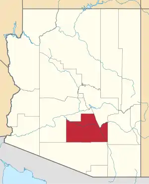 | |
| Towns | ||
| CDPs |
| |
| Populated places | ||
| Indian reservations | ||
| Ghost towns | ||
| Footnotes | ‡This populated place also has portions in an adjacent county or counties | |