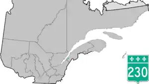
Route 230 | ||||
|---|---|---|---|---|
 | ||||
| Route information | ||||
| Maintained by Transports Québec | ||||
| Length | 53.1 km[1] (33.0 mi) | |||
| Major junctions | ||||
| West end | ||||
| East end | Saint-Alexandre-de-Kamouraska | |||
| Location | ||||
| Country | Canada | |||
| Province | Quebec | |||
| Highway system | ||||
| ||||

Route 230 is a two-lane east/west provincial highway on the south shore of the Saint Lawrence River in the Bas-Saint-Laurent region of Eastern Quebec, Canada. Its eastern terminus is in Saint-Alexandre-de-Kamouraska east of the junction of Route 289 and the western terminus is at the junction of Route 132 in La Pocatière.
Municipalities along Route 230
- La Pocatière
- Saint-Pacôme
- Saint-Philippe-de-Néri
- Saint-Pascal
- Sainte-Hélène-de-Kamouraska
- Saint-Alexandre-de-Kamouraska
 Route 230 western end is located in La Pocatière, west of downtown.
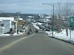
.jpg.webp) Quebec Route 230 in Saint-Pascal.
Quebec Route 230 in Saint-Pascal.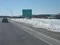 Eastern end of Route 230 is located at its junction with Route 289, near Autoroute 20.
See also
References
- ↑ Ministère des transports, "Distances routières", page 85-86, Les Publications du Québec, 2005
External links
- Provincial Route Map (Courtesy of the Quebec Ministry of Transportation) (in French)
- Route 230 on Google Maps.
This article is issued from Wikipedia. The text is licensed under Creative Commons - Attribution - Sharealike. Additional terms may apply for the media files.