Seurre | |
|---|---|
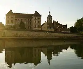 14th-century Saint-Martin Church and Saône River | |
.svg.png.webp) Coat of arms | |
Location of Seurre | |
 Seurre 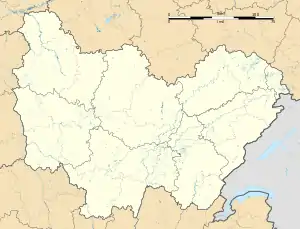 Seurre | |
| Coordinates: 46°59′57″N 5°08′51″E / 46.9992°N 5.1475°E | |
| Country | France |
| Region | Bourgogne-Franche-Comté |
| Department | Côte-d'Or |
| Arrondissement | Beaune |
| Canton | Brazey-en-Plaine |
| Intercommunality | Rives de Saône |
| Government | |
| • Mayor (2020–2026) | Alain Becquet[1] |
| Area 1 | 8.99 km2 (3.47 sq mi) |
| Population | 2,314 |
| • Density | 260/km2 (670/sq mi) |
| Time zone | UTC+01:00 (CET) |
| • Summer (DST) | UTC+02:00 (CEST) |
| INSEE/Postal code | 21607 /21250 |
| Elevation | 176–192 m (577–630 ft) (avg. 181 m or 594 ft) |
| 1 French Land Register data, which excludes lakes, ponds, glaciers > 1 km2 (0.386 sq mi or 247 acres) and river estuaries. | |
Seurre (French pronunciation: [sœʁ]) is a commune in the Côte-d'Or department in eastern France.
This commune lies at the crossroad of routes to Dijon, Chalon-sur-Saône, Dole, Beaune, and Louhans.
Population
| Year | Pop. | ±% p.a. |
|---|---|---|
| 1968 | 2,683 | — |
| 1975 | 2,822 | +0.72% |
| 1982 | 2,694 | −0.66% |
| 1990 | 2,728 | +0.16% |
| 1999 | 2,666 | −0.26% |
| 2007 | 2,473 | −0.93% |
| 2012 | 2,436 | −0.30% |
| 2017 | 2,353 | −0.69% |
| Source: INSEE[3] | ||
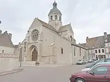
Church of Seurre
See also
References
- ↑ "Répertoire national des élus: les maires" (in French). data.gouv.fr, Plateforme ouverte des données publiques françaises. 13 September 2022.
- ↑ "Populations légales 2021". The National Institute of Statistics and Economic Studies. 28 December 2023.
- ↑ Population en historique depuis 1968, INSEE
External links
Wikimedia Commons has media related to Seurre.
This article is issued from Wikipedia. The text is licensed under Creative Commons - Attribution - Sharealike. Additional terms may apply for the media files.