Sihuas | |
|---|---|
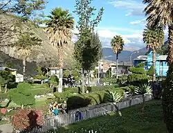 The town Sihuas, seat of the province | |
 Coat of arms | |
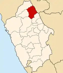 Location of Sihuas in the Ancash Region | |
| Country | Peru |
| Region | Ancash |
| Capital | Sihuas |
| Area | |
| • Total | 1,455.97 km2 (562.15 sq mi) |
| Population | |
| • Total | 30,849 |
| • Density | 21/km2 (55/sq mi) |
| UBIGEO | 0219 |
| Website | www |
The Sihuas Province (Quechua Siwas) is one of twenty provinces of the Ancash Region in Peru.This province was created by Law nº 13485, dated at January 9 of 1961, when was president of Perou: Manuel Prado.[1] It is bordered by provinces of Huaylas and Corongo on the west, Pallasca Province on the north, La Libertad Region on the east, and Pomabamba Province on the south.[2]
Geography
One of the highest peaks of the district is Puka Qaqa at approximately 4,400 m (14,400 ft). Other mountains are listed below:[3]
- Aya K'uchu
- Chawpi Qaqa
- Hatun Anqas
- Hatun Hirka
- Kiswar
- Kuntur Wasi
- Kushuru Pampa
- Kushuru Pata
- Mach'ay Wayi
- Minas Hirka
- Minas Pampa
- Misa Pata
- Ñawin Qucha
- Pilanku
- Pukara
- Punta Hirka
- Putaqa
- Q'ala Marka
- Qulluta
- Raqay Qucha
- Rima Pampa
- Silla Hirka
- Sumaq Pampa
- Suyru Pampa
- Tuku Mach'ay
- Uqa Chakra
- Waraqayuq
- Wathiyana Hirka
- Wathiyayuq
- Wayanay
- Waychu Mach'ay
- Wiru Kancha
- Yawar Qucha
Political division
Sihuas is divided into ten districts, which are:
Ethnic groups
The province is inhabited by indigenous citizens of Quechua descent. Spanish is the language which the majority of the population (62.89%) learnt to speak in childhood, 36.83% of the residents started speaking using the Quechua language (2007 Peru Census).[4]
Earthquake of November 10, 1946
On November 10, 1946, a magnitude 7.3 earthquake struck the province. The epicenter is estimated to have occurred at 8°20' S. 77°50' W. at a depth of 30 – 40 km. The surface fault was observed to run about 18 km northwest from Quiches toward Conchucos. The quake was "the first well-observed instance of major faulting."[5] The fault was purely slip-dip (vertical), with an offset of as much as 3.5 meters (11 feet). The quake and resulting landslides resulted in a death toll estimated at 1400 - 1700,[6] a substantial number given the sparse population in the area. The village of Acobamba was buried by one landslide, killing 217.
Main events
References
- ↑ Back page of book "Cómo resurge una Provincia Bolivariana" ISBN 978-612-00-1099-0
- ↑ (in Spanish) Instituto Nacional de Estadística e Informática. Banco de Información Digital Archived 2008-04-23 at the Wayback Machine. Retrieved June 15, 2008.
- ↑ escale.minedu.gob.pe/ UGEL map Sihuas Province (Ancash Region)
- ↑ inei.gob.pe Archived 2013-01-27 at the Wayback Machine INEI, Peru, Censos Nacionales 2007
- ↑ Charles F. Richter, Elementary Seismology (San Francisco, W.H. Freeman and Co. 1958) p. 768, quoted in Historic Earthquakes.
- ↑ Newspaper "El Comercio" of Lima, November 1946, National Library of Peru
- ↑ Free traduction, as other cases
- ↑ Unyén Velezmoro: "La enciclopedia de Áncash" ISBN 978-612-00-0672-6
Sources
- Historic Earthquakes
- Alexander E. Gates and David Ritchie, Encyclopedia of Earthquakes and Volcanoes, Third Ed. (New York, Facts on File, Inc. 2007) p. 10 available at Scribd
External links
- (in Spanish) Municipal web site
| |
|---|---|
8°34′01″S 77°37′01″W / 8.567°S 77.617°W