| Sormonne | |
|---|---|
_pont_sur_la_Sormonne.JPG.webp) | |
  | |
| Location | |
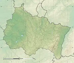
| Country | France |
| Physical characteristics | |
| Source | |
| • location | Taillette |
| • coordinates | 49°54′48″N 04°26′56″E / 49.91333°N 4.44889°E |
| • elevation | 350 m (1,150 ft) |
| Mouth | Meuse |
• coordinates | 49°46′18″N 04°41′04″E / 49.77167°N 4.68444°E |
• elevation | 140 m (460 ft) |
| Length | 56.4 km (35.0 mi) |
| Basin size | 411 km2 (159 sq mi) |
| Discharge | |
| • average | 6.36 m3/s (225 cu ft/s) |
| Basin features | |
| Progression | Meuse→ North Sea |
The Sormonne (French pronunciation: [sɔʁmɔn]) is a 56.4 km (35.0 mi) long river in the Ardennes département, northeastern France.[1] Its source is at Taillette, near Rocroi. It flows generally southeast. It is a left tributary of the Meuse into which it flows at Warcq, near Charleville-Mézières.
Communes along its course
This list is ordered from source to mouth: Taillette, Éteignières, Regniowez, Neuville-lez-Beaulieu, Auvillers-les-Forges, Girondelle, Flaignes-Havys, Marby, Étalle, Blombay, Chilly, Laval-Morency, Le Châtelet-sur-Sormonne, Murtin-et-Bogny, Sormonne, Remilly-les-Pothées, Ham-les-Moines, Haudrecy, Cliron, Tournes, Belval, Damouzy, Warcq
References
This article is issued from Wikipedia. The text is licensed under Creative Commons - Attribution - Sharealike. Additional terms may apply for the media files.