Stolpe auf Usedom | |
|---|---|
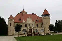 Stolpe Castle | |
Location of Stolpe auf Usedom within Vorpommern-Greifswald district 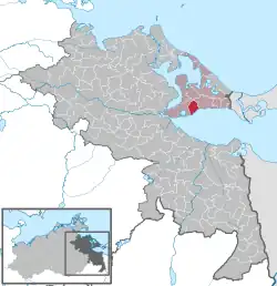 | |
 Stolpe auf Usedom  Stolpe auf Usedom | |
| Coordinates: 53°52′N 14°00′E / 53.867°N 14.000°E | |
| Country | Germany |
| State | Mecklenburg-Vorpommern |
| District | Vorpommern-Greifswald |
| Municipal assoc. | Usedom-Süd |
| Government | |
| • Mayor | Eckhardt Schulz |
| Area | |
| • Total | 14.86 km2 (5.74 sq mi) |
| Elevation | 0 m (0 ft) |
| Population (2021-12-31)[1] | |
| • Total | 369 |
| • Density | 25/km2 (64/sq mi) |
| Time zone | UTC+01:00 (CET) |
| • Summer (DST) | UTC+02:00 (CEST) |
| Postal codes | 17406 |
| Dialling codes | 038372 |
| Vehicle registration | VG |
Stolpe auf Usedom is a municipality in the Vorpommern-Greifswald district, in Mecklenburg-Vorpommern, Germany.
References
- ↑ "Bevölkerungsstand der Kreise, Ämter und Gemeinden 2021" (XLS) (in German). Statistisches Amt Mecklenburg-Vorpommern. 2022.
External links
![]() Media related to Stolpe auf Usedom at Wikimedia Commons
Media related to Stolpe auf Usedom at Wikimedia Commons
This article is issued from Wikipedia. The text is licensed under Creative Commons - Attribution - Sharealike. Additional terms may apply for the media files.