 TIROS-9 satellite | |
| Mission type | Weather satellite |
|---|---|
| Operator | NASA |
| COSPAR ID | 1965-004A |
| SATCAT no. | 978 |
| Spacecraft properties | |
| Spacecraft type | TIROS |
| Manufacturer | RCA / GSFC |
| Launch mass | 138.30 kilograms (304.9 lb)[1] |
| Dimensions | 1.07 m × 0.56 m (3.5 ft × 1.8 ft) |
| Start of mission | |
| Launch date | January 22, 1965, 07:52 UTC[2] |
| Rocket | Thor-Delta C 374/D-28 |
| Launch site | Cape Canaveral LC-17A |
| End of mission | |
| Last contact | February 15, 1967 |
| Orbital parameters | |
| Reference system | Geocentric |
| Regime | Low Earth |
| Eccentricity | 0.11693[1] |
| Perigee altitude | 705 kilometers (438 mi)[1] |
| Apogee altitude | 2,582 kilometers (1,604 mi)[1] |
| Inclination | 96.43°[1] |
| Period | 119.23 minutes[1] |
| Epoch | January 22, 1965[1] |
| Instruments | |
| Television Camera System | |
TIROS-9 (also called TIROS-I or A-54) was a spin-stabilized meteorological satellite. It was the ninth in a series of Television Infrared Observation Satellites.
Launch
TIROS-9 was launched on January 22, 1965, by a Thor-Delta rocket from Cape Canaveral Air Force Station, Florida. The spacecraft functioned nominally until February 15, 1967. The satellite orbited the Earth once every 2 hours, at an inclination of 96°. Its perigee was 705 kilometers (438 mi) and apogee was 2,582 kilometers (1,604 mi).[1]
Mission
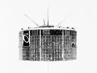
TIROS-9 was a spin-stabilized meteorological spacecraft designed to test experimental television techniques and infrared equipment. The satellite was in the form of an 18-sided right prism, 107 cm in diameter and 56 cm high. The top and sides of the spacecraft were covered with approximately 9000 1-by 2-cm silicon solar cells. It was equipped with 2 independent television camera subsystems for taking cloudcover pictures, plus an omnidirectional radiometer and a five-channel scanning radiometer for measuring radiation from the earth and its atmosphere. The satellite spin rate was maintained between 8 and 12 rpm by use of five diametrically opposed pairs of small, solid-fuel thrusters.
The TV system operated normally until April 1, 1965, when one of the wide-angle TV cameras failed. The other camera operated normally until July 26, 1965, and sporadically until February 15, 1967. TIROS 9 was the first satellite in the TIROS series to be placed in a near-polar orbit, thereby increasing TV coverage to the entire daylight portion of the Earth.[3]
References
- 1 2 3 4 5 6 7 8 "TIROS 9". National Space Science Data Center Master Catalog. NASA Goddard Space Flight Center. Retrieved June 4, 2018.
- ↑ McDowell, Jonathan. "Launch Log". Jonathan's Space Page. Retrieved June 4, 2018.
- ↑ "TIROS 9 (1965-004A)". NASA Goddard Space Flight Center. Retrieved June 4, 2018.
 This article incorporates text from this source, which is in the public domain.
External links
- Real Time Satellite Tracking - TIROS 9. N2yo.com
- Technical Summary of Polar Meteorological Satellites. pdf
TIROS satellites | ||
|---|---|---|
| TIROS |  | |
| TOS | ||
| ITOS | ||
| TIROS-N | ||
| Adv. TIROS-N | ||