Taoyaomen Bridge 桃夭门大桥 | |
|---|---|
 | |
| Coordinates | 30°06′N 121°58′E / 30.1°N 121.96°E |
| Carries | |
| Crosses | Taoyaomen Channel |
| Locale | Between Fuchi Island and Cezi Island, Zhoushan, Zhejiang province, |
| Characteristics | |
| Design | Cable-stayed |
| Total length | 888 m |
| Width | 27.6 m |
| Height | 151 m (495 ft) |
| Longest span | 580 m (1,903 ft) |
| No. of spans | 7 |
| Load limit | 2000 t[1][2] |
| Clearance above | 32 m |
| History | |
| Construction start | March 2001[1] |
| Construction end | April 2003[1] |
| Opened | 2003 |
| Statistics | |
| Daily traffic | 2 directions 4 lanes |
| Location | |
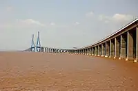
The Taoyaomen Bridge (Traditional Chinese: 桃夭門大橋, Simplified Chinese: 桃夭门大桥, Pinyin: táo yāo mén dà qiáo), is a cable-stayed bridge located in Zhoushan, Zhejiang Province of the PRC, that crosses the Taoyaomen Channel (Simplified Chinese: 桃夭门水道), linking Fuchi Island (Simplified Chinese: 富翅岛) and Cezi Island (Simplified Chinese: 册子岛).[1] It is the third bridge of the Zhoushan Islands-Linking megaproject (see: Zhoushan Trans-oceanic Bridges).[1]
Its seven spans are of 48m + 48m + 50m + 580m (main span) + 50m + 48m + 48m.
See also
References
- 1 2 3 4 5 "桃夭门大桥(Taoyaomen Bridge)" (in Chinese). Zhoushan Science & Technology. 2007-06-19. Archived from the original on 2011-07-07. Retrieved 2010-01-01.
- ↑ "桃夭门大桥(Taoyaomen Bridge)" (in Chinese). Dinghai News Agency. 2009-11-10. Retrieved 2010-01-01.
|
|  | |
This article is issued from Wikipedia. The text is licensed under Creative Commons - Attribution - Sharealike. Additional terms may apply for the media files.