Toronto, Indiana | |
|---|---|
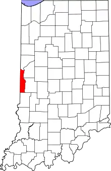 Vermillion County's location in Indiana | |
 Toronto Toronto's location in Vermillion County | |
| Coordinates: 39°46′54″N 87°29′44″W / 39.78167°N 87.49556°W | |
| Country | United States |
| State | Indiana |
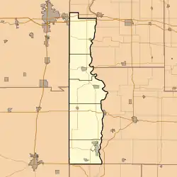
| County | Vermillion |
| Township | Helt |
| Elevation | 636 ft (194 m) |
| Time zone | UTC-5 (Eastern (EST)) |
| • Summer (DST) | UTC-4 (EDT) |
| ZIP code | 47847 |
| Area code | 765 |
| GNIS feature ID | 452163 |
Toronto is an extinct town in Helt Township, Vermillion County, in the U.S. state of Indiana.[2] The site is on Indiana State Road 71 near the Illinois and Indiana border.
A few buildings in the community exist, and it is still cited by the USGS.[3]
History
A post office was established at Toronto in 1838, and remained in operation until it was discontinued in 1912.[4]
Geography
Toronto is located at 39°46′54″N 87°29′44″W / 39.78167°N 87.49556°W.
References
- ↑ "US Board on Geographic Names". United States Geological Survey. October 25, 2007. Retrieved 2016-07-18.
- ↑ Hawes, George W. (August 31, 1859). "G. W. Hawes' Indiana State Gazetteer and Business Directory for 1858 and 1859". Geo. W. Hawes, Pub. and Proprietor.
- ↑ "Toronto, Indiana". Geographic Names Information System. United States Geological Survey, United States Department of the Interior. Retrieved 2016-07-18.
- ↑ "Vermillion County". Jim Forte Postal History. Retrieved 1 October 2015.
Municipalities and communities of Vermillion County, Indiana, United States | ||
|---|---|---|
| City | Map of Indiana highlighting Vermillion County | |
| Towns | ||
| Townships | ||
| CDPs | ||
| Other communities | ||
| Ghost towns | ||
| Footnotes | ‡This populated place also has portions in an adjacent county or counties | |
This article is issued from Wikipedia. The text is licensed under Creative Commons - Attribution - Sharealike. Additional terms may apply for the media files.