Craménil | |
|---|---|
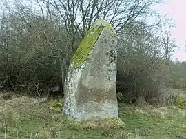 A menhir in Craménil | |
Location of Craménil | |
 Craménil 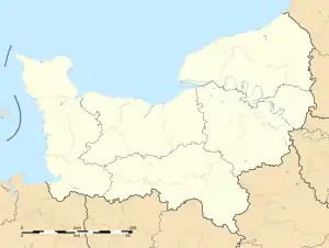 Craménil | |
| Coordinates: 48°44′42″N 0°22′37″W / 48.745°N 0.3769°W | |
| Country | France |
| Region | Normandy |
| Department | Orne |
| Arrondissement | Argentan |
| Canton | Athis-Val de Rouvre |
| Intercommunality | Val d'Orne |
| Government | |
| • Mayor (2020–2026) | Jean Onfroy[1] |
| Area 1 | 8.09 km2 (3.12 sq mi) |
| Population | 129 |
| • Density | 16/km2 (41/sq mi) |
| Demonym | Craménilois |
| Time zone | UTC+01:00 (CET) |
| • Summer (DST) | UTC+02:00 (CEST) |
| INSEE/Postal code | 61137 /61220 |
| Elevation | 174–253 m (571–830 ft) |
| 1 French Land Register data, which excludes lakes, ponds, glaciers > 1 km2 (0.386 sq mi or 247 acres) and river estuaries. | |
Craménil (French pronunciation: [kʁamenil] ⓘ) is a commune in the Orne department in north-western France.
Geography
The commune is made up of the following collection of villages and hamlets, Le Bois, Chênesec,La Morinière and Craménil.[3]
The commune is part of the area known as Suisse Normande.[4]
Neighbouring communes[3] | |
|---|---|
There are 3 watercourses that run through the commune, the River Rouvre and two streams the Maufy and the Haie.[5][6][7]
Notable buildings and places
National heritage sites
The Commune has 2 buildings and areas listed as a Monument historique[8]
- Four Bridges of the Rouvre a collection of 16-17th Centaury Toll Bridges, known as the Motte bridge, the Chênesecq bridge, the Neuf bridge and the Raulette bridge.[9] The bridges are the last evidence of 16-17th Centaury toll bridges and were used up to the end of the 19th Centaury, beginning of the 20th Centaury, when the mills they served closed down.[10] They wwere registered as a Monument historique in 1993.[9]
- The sharpener of Gargantua Menhir a Neolithic Menhir registered as a Monument historique in 1889.[11]
See also
References
- ↑ "Répertoire national des élus: les maires". data.gouv.fr, Plateforme ouverte des données publiques françaises (in French). 2 December 2020.
- ↑ "Populations légales 2021". The National Institute of Statistics and Economic Studies. 28 December 2023.
- 1 2 "Craménil · 61220, France". Craménil · 61220, France.
- ↑ "Map of Suiss Normande" (PDF).
- ↑ "Ruisseau de Maufy, Cours d'eau en France". www.annuaire-mairie.fr.
- ↑ "Rivière La Rouvre, Cours d'eau en France". www.annuaire-mairie.fr.
- ↑ "Ruisseau de la Haie, Cours d'eau en France". www.annuaire-mairie.fr.
- ↑ "Mairie de Craménil et sa commune (61220)". Annuaire-Mairie. 27 April 2023.
- 1 2 "Ponts sur la Rouvre, dits pont de la Motte, pont de Chênesecq, pont Neuf et pont de Raulette. à Craménil - PA00125311". monumentum.fr.
- ↑ "Ponts sur la Rouvre, dits pont de la Motte, pont de Chênesecq, pont Neuf et pont de Raulette". www.pop.culture.gouv.fr.
- ↑ "Menhir dit l'affiloir de Gargantua à Craménil - PA00110789". monumentum.fr.
Wikimedia Commons has media related to Craménil.
This article is issued from Wikipedia. The text is licensed under Creative Commons - Attribution - Sharealike. Additional terms may apply for the media files.