Noyellette | |
|---|---|
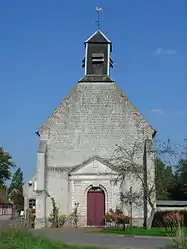 The church of Noyellette | |
 Coat of arms | |
Location of Noyellette | |
 Noyellette 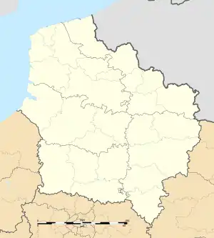 Noyellette | |
| Coordinates: 50°18′04″N 2°35′46″E / 50.3011°N 2.5961°E / 50.3011; 2.5961 | |
| Country | France |
| Region | Hauts-de-France |
| Department | Pas-de-Calais |
| Arrondissement | Arras |
| Canton | Avesnes-le-Comte |
| Intercommunality | CC Campagnes de l'Artois |
| Government | |
| • Mayor (2020–2026) | Nadine Vendeville[1] |
| Area 1 | 2.02 km2 (0.78 sq mi) |
| Population | 159 |
| • Density | 79/km2 (200/sq mi) |
| Time zone | UTC+01:00 (CET) |
| • Summer (DST) | UTC+02:00 (CEST) |
| INSEE/Postal code | 62629 /62123 |
| Elevation | 83–122 m (272–400 ft) (avg. 94 m or 308 ft) |
| 1 French Land Register data, which excludes lakes, ponds, glaciers > 1 km2 (0.386 sq mi or 247 acres) and river estuaries. | |
Noyellette is a commune in the Pas-de-Calais department in the Hauts-de-France region of France.[3]
Geography
Noyelette is situated 7 miles (11 km) west of Arras, on the D339 road.
Population
| Year | Pop. | ±% p.a. |
|---|---|---|
| 1968 | 104 | — |
| 1975 | 102 | −0.28% |
| 1982 | 155 | +6.16% |
| 1990 | 194 | +2.85% |
| 1999 | 183 | −0.65% |
| 2007 | 181 | −0.14% |
| 2012 | 181 | +0.00% |
| 2017 | 173 | −0.90% |
| Source: INSEE[4] | ||
Places of interest
- The church of St.Pierre, dating from the eighteenth century.
See also
References
- ↑ "Répertoire national des élus: les maires". data.gouv.fr, Plateforme ouverte des données publiques françaises (in French). 9 August 2021.
- ↑ "Populations légales 2021". The National Institute of Statistics and Economic Studies. 28 December 2023.
- ↑ INSEE commune file
- ↑ Population en historique depuis 1968, INSEE
External links
Wikimedia Commons has media related to Noyellette.
This article is issued from Wikipedia. The text is licensed under Creative Commons - Attribution - Sharealike. Additional terms may apply for the media files.