Reußenköge Reussenkog | |
|---|---|
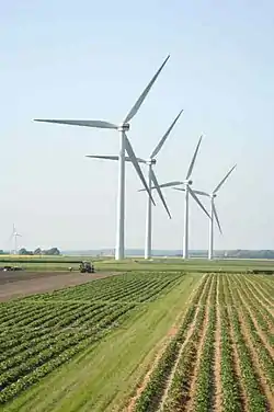 A wind farm in the Desmerciereskoog polder | |
 Coat of arms | |
Location of Reußenköge Reussenkog within Nordfriesland district 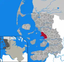 | |
 Reußenköge Reussenkog  Reußenköge Reussenkog | |
| Coordinates: 54°36′33″N 8°54′16″E / 54.60917°N 8.90444°E | |
| Country | Germany |
| State | Schleswig-Holstein |
| District | Nordfriesland |
| Government | |
| • Mayor | Dirk Albrecht |
| Area | |
| • Total | 45.91 km2 (17.73 sq mi) |
| Elevation | 1 m (3 ft) |
| Population (2022-12-31)[1] | |
| • Total | 321 |
| • Density | 7.0/km2 (18/sq mi) |
| Time zone | UTC+01:00 (CET) |
| • Summer (DST) | UTC+02:00 (CEST) |
| Postal codes | 25821 |
| Dialling codes | 04671, 04674, 04842 |
| Vehicle registration | NF |
| Website | www.reussenkoege.de |
Reußenköge (Danish: Reussenkog) is a sparsely populated municipality in the district of Nordfriesland, in Schleswig-Holstein, Germany. It is situated directly adjacent the shoreline of the North Sea coast, in a driving distance of in between 15 up to 29 km northwest of the county-capital city of Husum.
The municipality includes a number of six populated polders (German: Koog, plural: Köge), two of which were financed by Count Heinrich XLIII of Reuß-Schleiz-Köstritz and his wife Louise and thus bear the names Louisen-Reußen-Koog (const. 1799) and Reußenkoog (1789). Additional polders are:
- Sophien-Magdalenen-Koog (const. 1742)
- Desmerciereskoog (1767)
- Cecilienkoog (1905)
- Sönke-Nissen-Koog (1926)
- Beltringharder Koog (only unsettled northern part) (1987)
The name of the municipality was created by combining both the first names, meaning literally in English: polders of the Reußes. A further non-residential location within the municipality is the Hamburger Hallig. In former times being a settled part of the island of Alt-Nordstrand, it was split up from the rest by the Burchardi Flood in the year 1634.
References