Sumidouro | |
|---|---|
Municipality | |
| Município de Sumidouro | |
 Conde d'Eu Waterfall | |
 Flag  Seal | |
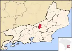 Location of Sumidouro in the state of Rio de Janeiro | |
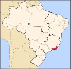
 Sumidouro Location of Sumidouro in Brazil | |
| Coordinates: 22°03′00″S 42°40′30″W / 22.05000°S 42.67500°W | |
| Country | |
| Region | Southeast |
| State | |
| Government | |
| • Prefeito | Eliesio Peres da Silva (PMDB) |
| Area | |
| • Total | 395.516 km2 (152.710 sq mi) |
| Elevation | 355 m (1,165 ft) |
| Population (2020 [1]) | |
| • Total | 15,667 |
| Time zone | UTC−3 (BRT) |
| Website | |
Sumidouro (Portuguese pronunciation: [sumiˈdo(w)ɾu]) is a municipality located in the Brazilian state of Rio de Janeiro. Its population was 15,667 (2020) and its area is 395 km².[2]
References
Capital: Rio de Janeiro | |||||||||||
| Mesoregion Baixadas |
|  | |||||||||
| Mesoregion Centro Fluminense |
| ||||||||||
| Mesoregion Metropolitana do Rio de Janeiro |
| ||||||||||
| Mesoregion Noroeste Fluminense |
| ||||||||||
| Mesoregion Norte Fluminense |
| ||||||||||
| Mesoregion Sul Fluminense |
| ||||||||||
This article is issued from Wikipedia. The text is licensed under Creative Commons - Attribution - Sharealike. Additional terms may apply for the media files.