Chilhac | |
|---|---|
Commune | |
 | |
Location of Chilhac | |
 Chilhac 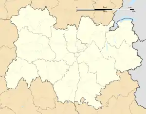 Chilhac | |
| Coordinates: 45°09′27″N 3°26′18″E / 45.1575°N 3.4383°E | |
| Country | France |
| Region | Auvergne-Rhône-Alpes |
| Department | Haute-Loire |
| Arrondissement | Brioude |
| Canton | Pays de Lafayette |
| Government | |
| • Mayor (2020–2026) | Michel Beckert[1] |
| Area 1 | 4.11 km2 (1.59 sq mi) |
| Population | 170 |
| • Density | 41/km2 (110/sq mi) |
| Time zone | UTC+01:00 (CET) |
| • Summer (DST) | UTC+02:00 (CEST) |
| INSEE/Postal code | 43070 /43380 |
| Elevation | 468–780 m (1,535–2,559 ft) (avg. 570 m or 1,870 ft) |
| 1 French Land Register data, which excludes lakes, ponds, glaciers > 1 km2 (0.386 sq mi or 247 acres) and river estuaries. | |
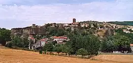
Chilhac (French pronunciation: [ʃijak]) is a commune in the Haute-Loire department in south-central France.
Population
| Year | Pop. | ±% p.a. |
|---|---|---|
| 1968 | 206 | — |
| 1975 | 183 | −1.68% |
| 1982 | 175 | −0.64% |
| 1990 | 181 | +0.42% |
| 1999 | 187 | +0.36% |
| 2009 | 198 | +0.57% |
| 2014 | 199 | +0.10% |
| 2020 | 167 | −2.88% |
| Source: INSEE[3] | ||
See also
References
- ↑ "Répertoire national des élus: les maires" (in French). data.gouv.fr, Plateforme ouverte des données publiques françaises. 13 September 2022.
- ↑ "Populations légales 2021". The National Institute of Statistics and Economic Studies. 28 December 2023.
- ↑ Population en historique depuis 1968, INSEE
Wikimedia Commons has media related to Chilhac.
This article is issued from Wikipedia. The text is licensed under Creative Commons - Attribution - Sharealike. Additional terms may apply for the media files.