Morro Agudo | |
|---|---|
 | |
 Flag  Coat of arms | |
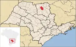 Location in São Paulo state | |
 Morro Agudo Location in Brazil | |
| Coordinates: 20°43′53″S 48°3′28″W / 20.73139°S 48.05778°W | |
| Country | Brazil |
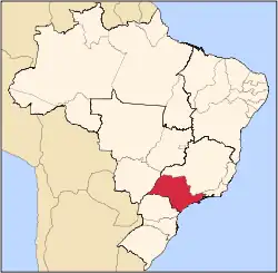
| Region | Southeast |
| State | São Paulo |
| Mesoregion | Ribeirão Preto · |
| Microregion | São Joaquim da Barra |
| Area | |
| • Total | 1,388 km2 (536 sq mi) |
| Population (2020 [1]) | |
| • Total | 33,288 |
| • Density | 24/km2 (62/sq mi) |
| Time zone | UTC−3 (BRT) |
Morro Agudo (Portuguese for "Sharp Hill") is a municipality in the state of São Paulo in Brazil. The population is 33,288 (2020 est.) in an area of 1388 km².[2] The elevation is 546 m. The city is the biggest Brazilian sugar-cane producer.[3]
See also
References
External links
 Media related to Morro Agudo at Wikimedia Commons
Capital: São Paulo | |||||||||||||||||||||
|  | ||||||||||||||||||||
|
| |||||||||||||||||||||
| |||||||||||||||||||||
| |||||||||||||||||||||
| |||||||||||||||||||||
| |||||||||||||||||||||
| |||||||||||||||||||||
| |||||||||||||||||||||
| |||||||||||||||||||||
| |||||||||||||||||||||
| |||||||||||||||||||||
| |||||||||||||||||||||
| |||||||||||||||||||||
This article is issued from Wikipedia. The text is licensed under Creative Commons - Attribution - Sharealike. Additional terms may apply for the media files.